HERO IMAGE — HIGHWAY CORRIDOR OVER TERRAIN
Replace with real capture
Highway & Corridor Engineering Includes Full AutoTerra Pro Spatial

AutoRoads

AutoTerra's all-inclusive highway and corridor engineering flagship. It takes a raw survey delivery — LiDAR, drone photogrammetry, or both — through terrain preparation, automatic greenfield route discovery, full horizontal and vertical alignment design, typical cross-sections and structures, to construction-ready plan & profile sheets, quantities and estimates. One seat that includes the entire AutoTerra Pro Spatial platform underneath.

7
stages, survey to deliverable
50B+
points per cloud supported
5
IRC discharge methods
64-bit
native Windows CAD engine
0
software boundaries crossed
Prepare

Survey Delivery → Design-Ready Surface

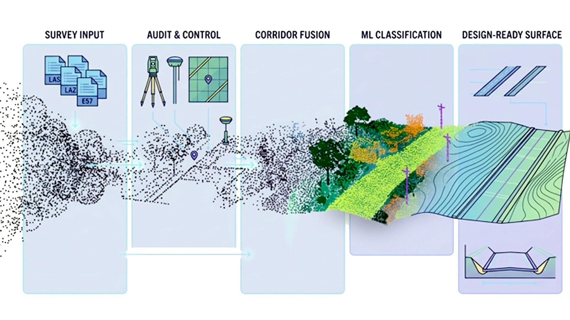
Every alignment starts with the survey handover — often an unclassified point cloud in a different coordinate system. Because AutoRoads contains the full AutoTerra Pro Spatial point-cloud platform, that delivery becomes a verified, classified design surface without leaving the project. Reproject the delivered cloud, audit it against ground control, and fuse LiDAR with drone photogrammetry where the corridor needs RGB context. The combined cloud runs through AutoTerra's LiDAR-grade classification engine — rolling-corridor routines tuned for long, steep, vegetated alignments — and the classified ground becomes the TIN design surface.

LAS / LAZ / E57 / PTS / PLY GCP validation ML classification Constrained TIN Precision contours Slope & catchments
LAS/LAZ/E57/PTS/PLY — 50-billion-point clouds, ECEF → Indian grid / UTM reprojection
Total station, DGPS/GNSS & level books reduced, least-squares adjustment
Slope-based & corridor-constrained bare-earth extraction under dense vegetation
ML classification — ground, buildings, poles, vegetation; trainable custom models
Auto linear features — road edges, kerbs & centrelines seed the alignment
Constrained TIN, precision contours, grid/DEM comparison, cross-sections at any interval and long sections along any alignment
Triangulation viewport showing drone imagery reconstructed into a dense point cloud
Routing & Alignment
Route

Greenfield Routing → Alignment Design

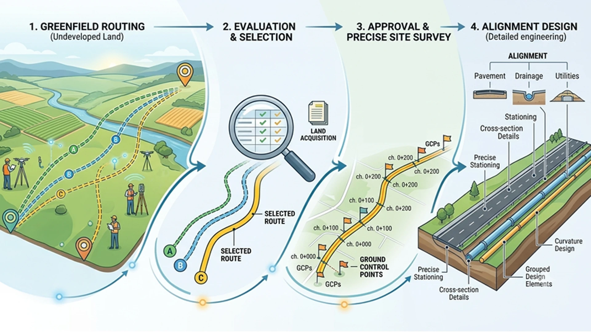
This is the AutoRoads difference: the route isn't sketched by hand. A global least-cost search engine studies the whole terrain and proposes constructible alignments. Give the engine the start, the end and the design policy — it searches the entire terrain with a grade- and radius-aware global optimiser and returns ranked route options, each with length, maximum grade, earthwork index and the structures it would need.

Global least-cost search Grade-feasible routing Auto bridge/tunnel placement Avoid-region constraints
Global least-cost corridor search across the full terrain model
Grade-feasible with a hard minimum radius — hairpin-aware for steep terrain
Ranked options with automatic cost-driven bridge & tunnel placement
Per-option report — length, max grade, earthwork index & grade utilisation
Avoid regions & boundary polygons constrain the search space
Options land as tangent-intersection design alignments — no re-digitising
Only in AutoRoads

Conventional road software asks you to draw a line and then tells you what is wrong with it. AutoRoads inverts the workflow: the terrain itself proposes the alignment. In mountainous corridors this replaces weeks of manual corridor studies with a documented, repeatable optimisation run.

Design

Alignment Design — Horizontal & Vertical, In Sync

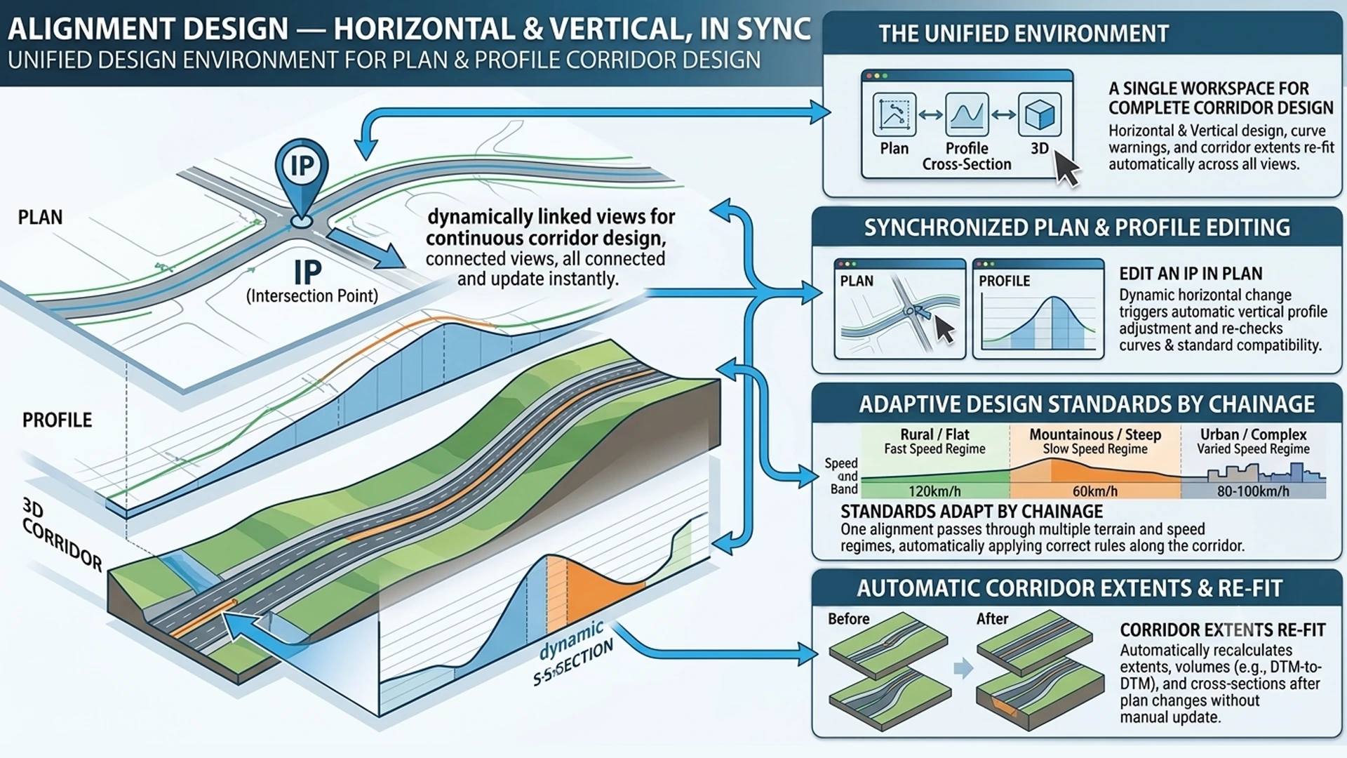
A unified corridor design environment where plan and profile stay in full sync: edit an IP in plan and the vertical design, curve warnings and corridor extents re-fit automatically. Design standards adapt by chainage, so one alignment can pass through multiple terrain and speed regimes.

IP-based horizontal VIP vertical by K-value Auto superelevation Real-time toe recalculation
IP-based horizontal — spirals, compound & reverse curves; VIP vertical by K-value
Automatic superelevation & camber per standard, with superelevation report
Real-time toe recalculation — corridor extents update as horizontal or vertical alignment changes
Speed- & terrain-driven radii, lane configs & extra widening from the standards library
Dynamic plan–profile updates — grades auto-refit after each horizontal edit
Multi-reference profiles & per-curve compliance warnings
Alignment Design
Parametric Structures
Structures · Drain

Parametric Structures & IRC Cross-Drainage

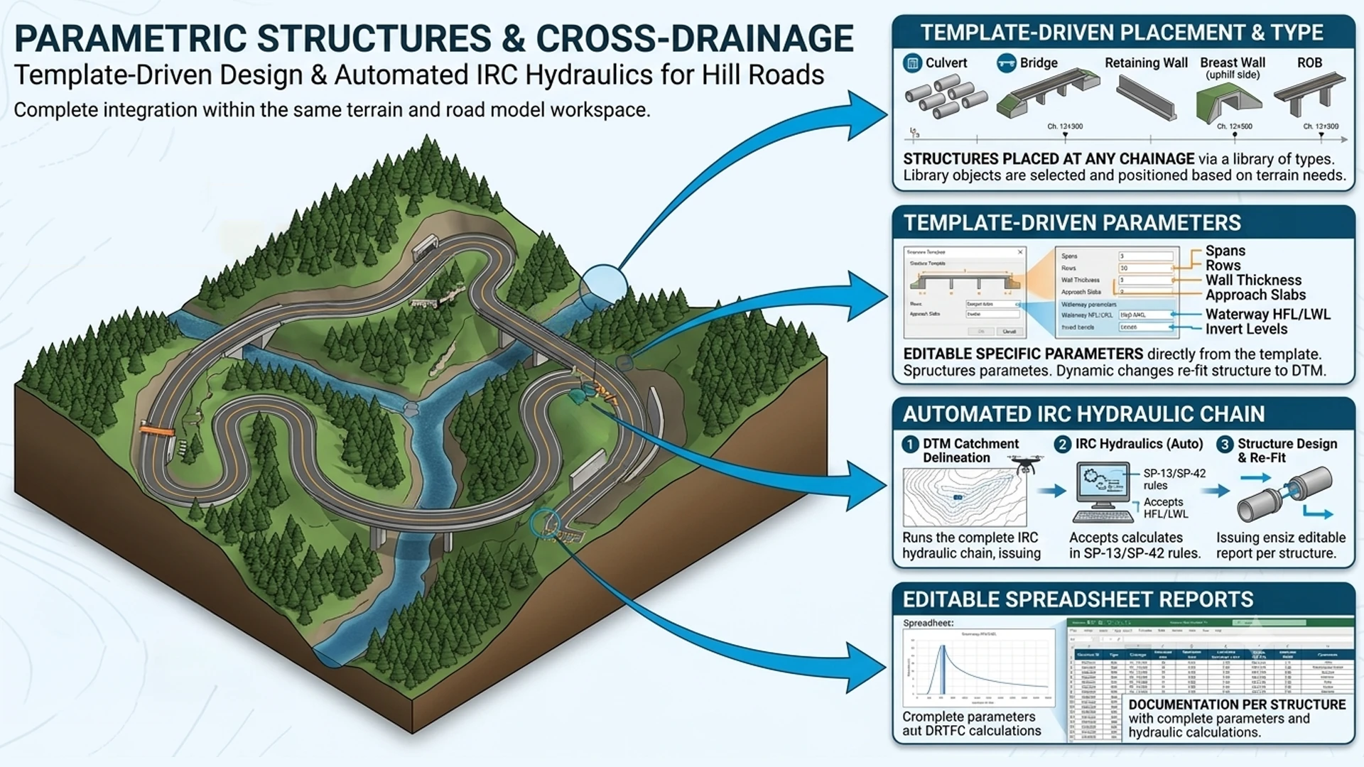
Culverts, bridges, retaining and breast walls, VUPs and ROBs are placed as parametric objects at any chainage — spans, rows, wall thickness, approach slabs, waterway HFL/LWL and invert levels all template-driven. Every hill road lives or dies by its cross-drainage: AutoRoads delineates the catchment at each crossing on the same DTM and runs the complete IRC hydraulic chain, issuing an editable spreadsheet report per structure.

Parametric structures D8 flow analysis IRC discharge methods Lacey scour & foundation
Bridges, underpasses, box culverts, retaining/breast/RE walls, gabions & drains
Waterway data — HFL/LWL marking & invert levels per structure; structures follow the alignment through every edit
D8 flow analysis — accumulation, Strahler streams & pour-point catchments
IRC discharge — Dickens, Ryve's, Inglis, Rational & area-velocity methods
Lacey scour & foundation levels for piers and abutments per IRC:78; Molesworth afflux & vertical clearance checks
Editable XLSX design report with live formulas, one worksheet per structure; hydrology toolkit exports to HEC-RAS, ISIS & MIKE
Optimize · Produce

TCS, Detailing & Construction Deliverables

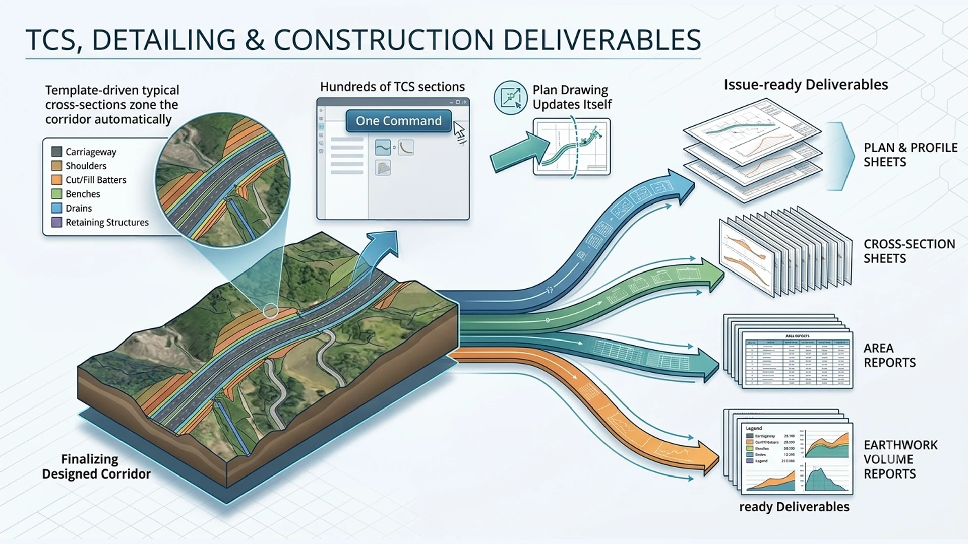
The designed corridor becomes buildable here: template-driven typical cross-sections zone the corridor automatically — carriageway, shoulders, cut/fill batters, benches, drains and retaining structures — with real-time visualisation as the design is tuned. One command finalises the corridor: hundreds of TCS sections generate into the alignment and the plan drawing updates itself. The production stage then turns the corridor model into issue-ready deliverables: plan & profile sheets, cross-section sheets, area reports and earthwork volume reports.

Template-based TCS Automated corridor zoning Plan & profile sheets Mass-haul diagram
Template-based TCS — formation, carriageway, shoulders, batters & berms; hill-road half-cut sections & benches
Automated corridor zoning along the alignment with construction-ready toe / setting-out reports
Automated plan & profile sheets — configurable layout & profile-band designer, with title block, scale, north arrow & legend on every sheet
Cut/fill by trapezoidal & Simpson's rules with prismoidal correction
Multi-sheet cross-section & longitudinal-section drawings at any interval, with flexible labelling across plan, profile & sections
Mass-haul diagram, borrow/waste balance & per-km cost summary
Template-based TCS
ROAD ESTIMATOR - Chainage-wise sections with quantities
Extend Beyond

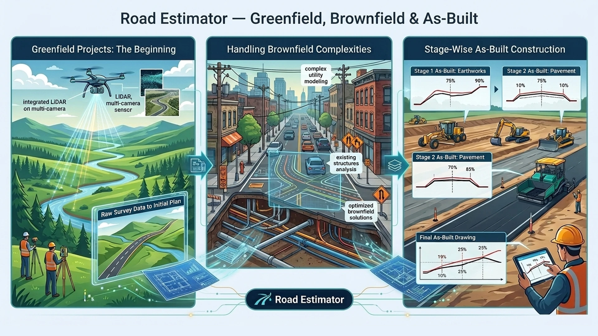
Road Estimator — Greenfield, Brownfield & As-Built

Beyond greenfield corridors, Road Estimator handles greenfield & brownfield projects — from automatic cross-sections off raw survey data to stage-wise as-built drawings during construction.

Auto cross-sections straight from survey data, with earthwork quantities
Automatic profile-correction for widening & strengthening schemes
Automatic PCC — detects the existing road; multi-layer, depth-based correction
Unlimited templates — multilane, service roads, expressways, NH, any road type
As-built drawings from periodic site levels at each construction stage
Editions

Where AutoRoads fits

All editions include the 3D viewer and basic annotation. Upgrade at any time — your project files and settings transfer seamlessly.

AutoTerra Pro Spatial

Point-cloud, terrain & LiDAR at scale — no highway design

Point-cloud processing & classification
Terrain modelling, sections & volumes
GIS-in-CAD
Greenfield route discovery
Alignment, structures & TCS design

AutoRoads You are here

Full highway & corridor engineering — survey to construction-ready deliverables

Everything in Pro Spatial
Greenfield least-cost route discovery
Horizontal & vertical alignment design
Parametric structures & IRC hydraulics
TCS, plan & profile production

Road Estimator

Add-on for greenfield/brownfield quantities & as-built tracking

Auto cross-sections from raw survey data
Automatic PCC & profile correction
Unlimited road-type templates
Stage-wise as-built drawings

See AutoRoads take your own survey data from delivery to deliverables

Contact our team at sales@autoterra.net to arrange a demonstration on your own project data.

Request a demo Start free trial